Govind Nagar, Lane No 05, P.O - Kandoli, Sahastradhara Road, Dehradun
We are an Independent GIS System Integrator and focuses on end to end offerings in geospatial information services. Our offerings includes GIS Consultancy Services, GIS System Development & Implementation, off-the-rack Integration, Testing & Maintenance for various verticals, GIS Data Design & Modelling, Data Migration, Capture, Validation, Maintenance (including remote maintenance), customer application development, web-based GIS for internal project management & for external customers, Geodatabase design configuring RDBMS establishing a multiuser editing environment, Standalone and web/mobile GIS application development.
We offers Geospatial services for Telecom, Electric, Water & Sewer, Waste water, Gas, Land base and all other Utility Domain.
GIS Data Conversion
The increasing role of spatial information has contributed to an ever-increasing set of standards and range of data formats for use. Different computer systems employ source data in dissimilar formats. With TGS leading data conversion software, data interoperability is no longer a tedious job.
Incompatible data formats can be a big challenge when migrating data across applications, this includes data that is non-digital (paper maps and other similar sources) and digital but in a different format. Our experienced team takes care of both these needs.
With the help of efficient software, analog data in the form of maps, reports and charts is scanned, manually digitized and converted into a standard GIS format. Non-traditional GIS data, such as satellite imagery, orthophotographs and digital terrain data which is often tedious to combine with GIS systems but yet is of an enormous value is seamlessly converted to an acceptable format that can be rendered by most common tools.
At TGS, we believe that quality management must work alongside all work relating to GIS management. For use data conversion doesn’t stop at changing formats and making data more compatible for the next computer system or application software, but we guarantee that quality practices are meticulously followed and business standards are maintained.

GIS Geodatabase Design, Development & Management
TGS has guided several clients from outdated file based GIS systems to highly scalable, high performance and secures Geo-database implementations. We provide expertise and consulting in the most sought after Geo-database architectures.
Along with design, TGS provides support and maintenance services for geodatabases that include periodic enhancements to ensure updated version of the geographic assets to reflect topographic changes in the real world.

Geospatial Data Warehouse & Data Mining
At TGS, we implement DWH solutions for enterprises with spatial and administrative data integrated together to help increase their business value.
Spatial data in large volumes can often be redundant. It is extremely important to derive crucial findings from effective analysis of such data to facilitate effective utilization of time and prevent operational delays.
TGS offers a complete DWH solution that not only involves storing and retrieving of spatial data, but also analyzes, reports and presents it based on specific business value.
Open Source SDI
TGS introduces some of the amazing open source Spatial Data Infrastructure available. There is much more to an SDI than just a standalone desktop or web GIS application.
SDI is a framework of geographic data, technologies, metadata, institutional arrangements and standards that facilitate the creation, exchange and use of geospatial data across an information-sharing community. This community can be at an organization level, national level or global level.
In all cases, SDI facilitates a standardized, automated means of evaluating and exchanging crucial geospatial information and other related resources.

Enterprise Web GIS
‘TGS for Enterprise’ is a platform offering a complete GIS solution that runs on your infrastructure, behind your firewall and is integrated seamlessly with your enterprise systems and complies with your standards.
With the web version, the platform is hosted on a cloud which means syncing and exchange of crucial geographic information can happen on the go, without the need to handle cumbersome server maintenance and disposal.
Implementing Enterprise GIS in your organization’s core functioning has two central advantages. One is the exchange and use of crucial geospatial information across groups, departments and offices. It allows all your staff to tap into the power of geospatial analytics. Second is the integration of this data with various important enterprise software such as SAP, Billing Systems etc. that might use a spatial component for analysis to derive data holding significant business value.
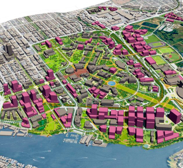
Urban Master Planning
TGS is a proud pioneer in the field of urban master planning for smart cities. From strategic city landscape planning to detailed local area plans, we ensure that all perspectives for topographical assessment are captured.
The assessment is made on various factors such as transportation plan, strategic land use and optimal disbursing of public services. Likewise, details such as population density and industrial fields are taken into account.
The findings are laid out in the form of a master plan that would guide the development of the city for years to follow.
GIS MIS Integration
An enterprise cannot function effectively if an optimal flow/exchange of information is missing. This is where MIS comes to rescue. Management Information Systems facilitate operation of crucial data repositories that hold data of significant business value. This data can be used by groups, divisions or departments within the enterprise based on business requirements, or for knowledge sharing and use of best practices in general.
Integrating GIS with MIS takes ICT to the next level. There is no questioning the significance of geo-spatial data for businesses today. Location can be an important variable in understanding trends and tracking real time data.
Moreover, it has enormous value for lines that require monitoring of territories and analyzing trends. For instance, a forest department might wish to track and analyze details such as forest fires, encroachment, animal injury, man-animal conflict and more- all in real time. This can be made possible with the aid of GIS enabled smart phones or portable devices to track the location and a GIS-MIS System to view, track and analyze the findings.